Monash University logo

Monash Art, Design and Architecture Graduate Exhibition 2025

Maribyrnong Industrial Corridor: A Contested Ground

Situated seven kilometres west of Melbourne’s CBD, the Maribyrnong Industrial Corridor has long been a landscape of production and mobility shaped by the river, the Port of Melbourne, and major road and rail infrastructure. As heavy industry has declined and new population and economic pressures emerge, large areas have become underutilised, creating competing demands for industrial retention and mixed-use redevelopment. Environmental legacies and social impacts add complexity, positioning the corridor at the intersection of regeneration, industry, and equity.

The Pioneer of Melbourne’s Industrial Era

The Maribyrnong River has long shaped Melbourne’s west, sustaining the Wurundjeri Woi Wurrung and Bunurong peoples for thousands of years. With colonisation, the river became an industrial engine, accelerated by the 1858 railway bridge, Yarraville Wharf, and the Coode Canal. By the early twentieth century, factories and refineries dominated the corridor. Although heavy industry later declined, adaptive reuse has emerged, and the area’s strategic location and port access continue to support logistics, light industry, and sustainable urban regeneration.

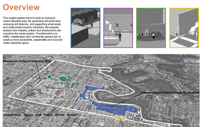
Sites for a More Inclusive City

Our approach addresses key challenges in the Maribyrnong mixed-use industrial area, including mobility issues, land-use conflicts, and social inequities, by translating them into site-specific design responses. Four demonstration sites serve as testing grounds, each representing distinct urban conditions from port logistics zones to creative industry and community precincts. These projects' trials improved active transportation, integrated light industry, and activated underutilised land, creating community workspaces that shaped a scalable model for inclusive urban transformation.

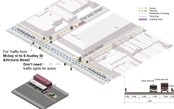
Proposal Site 4 I Shared Accessibility & Sustainable Logistics

The Maribyrnong–Coode Island corridor is vital to Melbourne’s freight network but faces fragmented logistics, high truck volumes, and inefficient last-mile distribution. A spatially integrated strategy is needed to link the Port, industry clusters, and local businesses. Proposed Freight Consolidation Centres (FCCs) at 325 and 221 Whitehall Street streamline goods movement by integrating freight, waste, and recycling systems, reducing truck trips, and supporting low-emission deliveries. This approach aligns with circular economy and climate goals while strengthening the local industry.

Proposal Site 4 I Freight Consolidation Centre for Light Industries

The proposed Freight Consolidation Centre for light industries at 221 Whitehall Street occupies 10.2 hectares along the Maribyrnong River and accommodates a multi-storey warehouse with a four-storey waste collection centre. With a 63% BCR and 37% open space, the design balances operations and public realm needs. Increasing the FAR to 1.5 and height to 18 metres allows 34 modular warehouse units. Yard depths of 30–36 metres and separated routes for heavy and light vehicles support efficient, safe, and sustainable logistics movements.

Explore more


View all


Back to top