Coarse-to-Fine: Multi-source Fusion for Precipitation Field Reconstruction
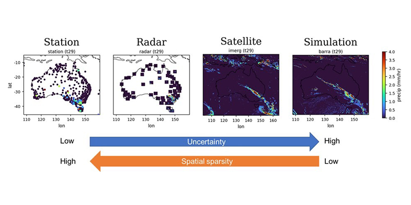
Precipitation is a key component of the global water cycle and plays a critical role in understanding extreme weather events. In Australia, high spatial and temporal resolution precipitation data, particularly at sub-hourly scales, are essential for capturing short-duration extreme rainfall, supporting flash flood forecasting, and improving risk assessment for climate-sensitive infrastructure. However, existing datasets are often limited by either sparse observations (e.g., rain gauges and radar) or coarse spatial–temporal resolution (e.g., satellite and reanalysis products), making it difficult to capture these events accurately.
This project aims to generate high-resolution precipitation data by integrating multiple complementary data sources, leveraging their respective strengths to produce more accurate and spatially consistent rainfall estimates across Australia. It will develop an AI-based framework for multi-source precipitation refinement, enabling improved analysis of extreme events and supporting climate and environmental applications.
Researchers
-

Dr Shixue Li
ARC Centre of Excellence for the Weather of the 21st Century
-
Skye Williams-Kelly
PhD student, University of New South Wales
-
Dr Richard Scalzo
Senior Lecturer
-

Professor Iadine Chades
Director, Environmental Informatics Hub; Discipline Lead, Translational AI
-

Associate Professor Ailie Gallant
School of Earth Atmosphere and Environment, Faculty of Science
-
Professor Julie Arblaster
ARC Centre of Excellence for the Weather of the 21st Century
-
Professor Lisa Alexander
University of New South Wales
-
Dr Johan Barthélemy
NVIDIA