3D Printed Maps to Support Orientation and Mobility
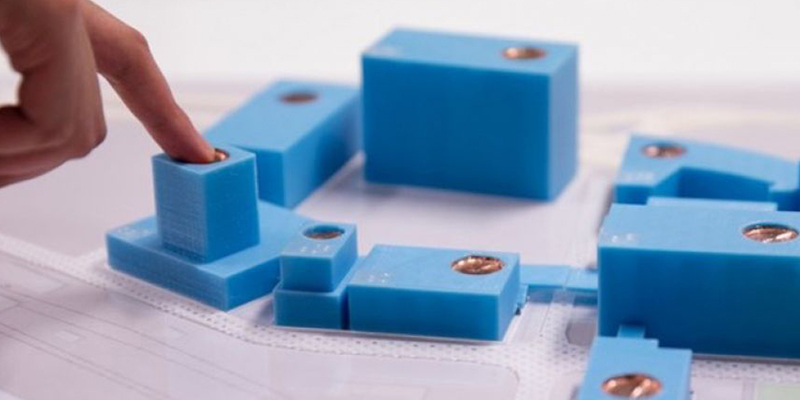
Tactile representations of the environment are critical to assist people who are blind or have severe low vision to build up an understanding of their surroundings to support safe and independent travel. However, traditional raised line drawings use a high level of abstraction and rely on understanding of the visual concept of a “birds eye view”.
Our research provided evidence that 3D printed maps can be more intuitive and easier to understand by touch. Working with our community collaborators, we created 3D printed tactile maps for real-world use, exploring their advantages and developing guidelines for their design.
The Outcome
3D printing components are available for free download on Thingiverse to create street map puzzle pieces and customisable street crossing maps, as well as TactIcons (tactile map icons) for use on a wide variety of maps.
You can find an example of our talking maps in the reception area of Vision Australia's head office in Kooyong, Victoria.
Selected papers
- Leona Holloway, Kim Marriott & Matthew Butler (2018). Accessible Maps for the Blind: Comparing 3D Printed Models with Tactile Graphics, CHI Conference on Human Factors in Computing Systems.
- Leona Holloway, Kim Marriott, Matthew Butler & Samuel Reinders (2019). 3D Printed Maps and Icons for Inclusion: Testing in the Wild by People who are Blind or have Low Vision, ASSETS Conference on Computers and Accessibility
- Leona Holloway, Matthew Butler & Kim Marriott (2022). 3D Printed Street Crossings: Supporting Orientation and Mobility Training with People who are Blind or have Low Vision, CHI Conference on Human Factors in Computing Systems (Best Paper Award).
- Ruth Nagassa, Matthew Butler, Leona Holloway, Cagatay Goncu & Kim Marriott (2023). 3D Building Plans: Supporting Navigation by People who are Blind or have Low Vision in Multi-Storey Buildings, CHI Conference on Human Factors in Computing Systems.
- Leona Holloway, Matthew Butler & Kim Marriott (2023) TactIcons: Designing 3D Printed Map Icons for People who are Blind or have Low Vision, CHI Conference on Human Factors in Computing Systems (Honourable Mention Award).
Researchers
-
Dr Leona Holloway
Research Fellow, Project Officer
-

Professor Kim Marriott
Director, Monash Assistive Technology & Society
-

Associate Professor Matt Butler
Associate Dean (Graduate Research)