Underwhelmed, underwater and trampled by sheep: Representation of Encounters in the Australian sketches of William Westall, 1802-3
A presentation given at Fieldwork Sketches: Blurring the Lines between Art and Anthropology symposium, Royal Anthropological Institute of Great Britain and Ireland, London, 16 February 2024.
1803 marks the tail-end of our Global Encounters project’s focus period, yet it provides an example of a series of encounters between First Nations peoples and those who came from the seas – both from the far side of the globe, and the Southeast Asian neighbourhood. It is a fascinating moment, when agents of the British Crown realised that they were not really discoverers, but interlopers in an already well-established network between First Nations peoples and Southeast Asian mariners.
This story takes us to two locations: Yolngu land and sea country, on the eastern side of Arnhem Land, and a reef in the Coral Sea known – rather creatively – as Wreck Reef. Our focus is on the purpose and value of fieldwork sketches executed by the European visitors, and their existential precariousness in the age of sail. This is a Great Man or Great Youth story about 19 year old landscape artist-to-be, William Westall.
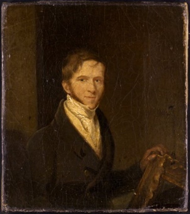
Figure 1 William Westall, Self Portrait C1820
This self portrait[1] is from 17 years later when he was approaching his forties, so we must imagine a more youthful Westall.
In 1800, thanks to a family connection to Sir Joseph Banks, teenage William Westall was appointed as landscape artist to a significant and well-funded project – the circumnavigation of Australia. Until this point, key parts of the coast were incomplete. Westall was not the first, second, or even third choice for the landscape artist role – other more senior artists had rejected the offer. Yet for a student in his first year of art training, this appointment represented a huge career opportunity.
The context of Westall’s contract is important. The 1780s saw the birth of copyright laws, spurred by unauthorised publication of James Cook’s travelogue. There was a huge appetite amongst the public for travel stories, and Cook’s journeys, especially, were a sensation. Yet at this time, there was little sense of copyright ownership, and the British Admiralty resented what were, in modern terms, bootleg copies of their hard-earned (and funded) records of explorations. A series of court cases between the Admiralty’s publishers and purveyors of ‘colourfully abridged’ versions of Cook journals tested the meaning of exclusive title.[2] By the time Westall’s services were being engaged two decades later, the Admiralty were carefully protecting their ownership of any sketches or art produced. The sketches and finished artwork produced on the voyage were to be the property of the Admiralty. Westall’s field sketches of the journey were NEVER to be Westall’s field sketches.
The leader of the expedition to circumnavigate Australia for the first time was similarly youthful Matthew Flinders, who was then 26. The crew was multinational and multi-skilled, and included a group who Flinders described numerous times as the ‘Scientific Gentlemen’ – botanical illustrator Ferdinand Bauer, plus a botanist, gardener, astronomer, and geologist.
On the trip out to Australia in 1802, William Westall suffered his first calamity at Madeira. After his first exploration ashore, he was nearly drowned on the way back to the ship, and all of his drawings were lost. This was to set an alarming precedent, and is a reminder of the fragility of fieldwork sketching. If the artist is going to do land-based sketches, they have to go from the ship via a transferring vessel, probably wade from there to the beach, using containers which possibly don’t match the waterproofing technology of today. So much can go wrong.
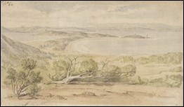
Figure 2 William Westall 1801, King George's Sound, view from the north-west, National Library of Australia
After five months at sea, including a not-unpleasant stop at the Cape Colony, young Westall – now 20 years old - first encountered the Australian coast. He diligently made sketches, some of which remain.[3] His sketches and just a few finished watercolours take us from King George’s Sound in western Australia,[4] to Thistle Island, off the south coast,[5] then eastward to Port Jackson or modern Sydney, where he sketched people and landscapes, and produced an oil painting of Government house.[6]
Figure 3 William Westall 1802, Thistle Island, National Library of Australia
Figure 4 William Westall, 1802, Sydney, Government House, National Library of Australia
Their journey then headed north to Mer or Murray Island (see Fig. 5),[7] with numerous stops and sketches along the way, and finally to the Gulf of Carpentaria and Arnhem land.
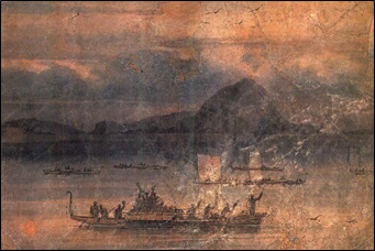
Figure 5 William Westall 1802, Murray Isles, National Library of Australia
By now it was early 1803 and Westall was 21 years old. On their explorations along the way, they had mainly experienced first encounter or early contact situations. These were mostly peaceable, due to Matthew Flinders’ disposition and the presence of Indigenous intermediaries. Tiffany Shellam’s Meeting the Waylo[8] gives a good sense of the importance of Bungaree, who travelled with Flinders. Yet there were also several tense or even outright hostile encounters, such as at Port Curtis and Keppel Island on the Queensland coast. These are discussed in detail in the records of Flinders and the Scientific Gentlemen.
But it was on Yolngu land, on the eastern tip of Anthem Land, that the most extraordinary encounter occurred. The Investigator crew truly met the unexpected.
What they found was a vibrant and extensive economic interaction sphere between Yolngu and mariners from the port of Makassar in Indonesia. The crews – all men – were Bugis, Toraja, Mandar, Samu Bajau, Javanese, and more. This iconic drawing by Henry Melville gives a sense what the Investigator crew might have seen.[9] We call these sailors and fishers Makassans, rather than Macassans as was preferred by Prof Campbell Macknight.
Figure 6 Macassans at Victoria, Port Essington by HS Melville, National Museum of Australia
This was a seasonal arrangement – the Makassans travelled south on the trade winds in search of beeswax, shark fin, and especially trepang or sea cucumbers. This trade network extended north to Makassar, on to the Philippines and eventually to China, where the fin and trepang were highly prized. And in fact they remain so, throughout the Asia-Pacific region.
The Investigator crew had arrived at the peak of trepang harvest season, when many dozens, perhaps hundreds of Makassan padiwakan or praus were working, in agreement with Indigenous owners, to collect, dry and export sea cucumbers. Flinders and the British called the maritime network the Malay Road. Today, we would call this the Spice Routes.
Until recently it was thought this trade began just a few decades before the British came, around 1700.[10] New research dates it much further back – Chris Urwin and colleagues argue convincingly for first exploratory visits a thousand years ago, and stages of increasing activity, which was terminated in 1907 when the Australian government outlawed the trade.[11] These severed connections, which had been built up over many centuries, separated families, and the modern ramifications of this have been explored in a recent Compass episode, The Lost Families.[12]
We also now know that this trade extended right across the top of Australia, from Western Australia to the Gulf of Carpentaria and probably beyond – archaeological and linguistic research is ongoing, continually pushing the area out and the dates back.
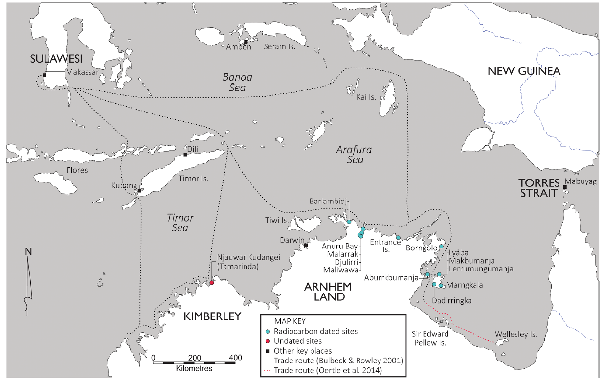
Figure 7 from Urwin et al 2023
This vibrant seasonal economy did not fit the expected narrative of isolated Indigenous peoples. And to some degree, the Australian coastline as a whole did not fit with William Westall’s expectations of lush, exotic and picturesque landscapes. He found them generally barren, though the tropical landscapes of Arnhem and land surrounding islands did offer some variety.[13] The surviving field sketches drawings tend to be sparse, and quite faint. Later, a handful of the sketches would result in works like Westall’s iconic ‘View of Malay Road from Pobassoo's Island, February 1803’.[14]
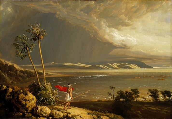
Figure 8 View of Malay Road from Pobassoo's Island, February 1803, Royal Museum Greenwich
This exquisite oil painting, which is currently exhibited at the Royal Museum Greenwich, represents the ideal outcome of Westall’s mission. The artist was to produce sketches in the field, come back, and turn them into art which could be either exhibited in museums, or replicated as lithographs in books to serve as triumphal catalogue of empire. In some ways, this grand oil painting of the unexpected encounter on Yolngu land and sea country represents a mission accomplished.
Yet, it almost didn’t happen.
The imperative was for Flinders and his charts of the coast and journals, plus the work done by the scientific gentlemen including Westall, to get back to London as soon as possible to be published. However, the Investigator itself was in a bad way – barely seaworthy, and unfit to make the voyage back to England, After Arnhem land, the Investigator turned east and backtracked to Port Jackson (modern day Sydney). Here, the travellers and their precious cargo of charts, sketches and journals transferred to the Porpoise which, along with two other ships, the Cato and the Bridgewater, began the return journey to England on 10 August 1803. The plan was to travel via Timor and India.
One week into this journey – in the Coral Sea - the three ships encountered a reef at night. The Porpoise and another ship, the Cato, were severely damaged.[15]
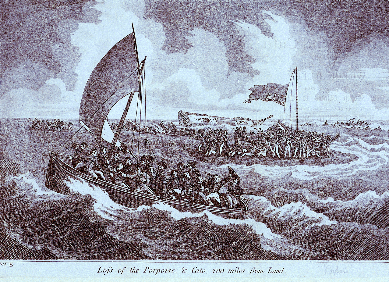
Figure 9 The Wreck of the Porpoise, Royal Museum Greenwich
Matthew Flinders’ first thought was to save his papers and charts – the most valuable cargo. He loaded them into a boat aiming for the Bridgewater, which had avoided the reef, but it was too far away and could not be reached. The Bridgewater promptly fled the scene to India, reported the Porpoise and Cato and their crews lost, then sailed away in shame (and undoubtedly fear of court martial) to an unknown fate.
Back on the stormy reef, in the dark, with both ships sinking, it must have been mayhem. Flinders struggled to protect his all-important charts and journals. We don’t know if Westall’s priority was his sketches or his life – he’d been traumatised by his earlier near-drowning at Madeira, and was just a few months shy of his 22nd birthday, so he may have had other priorities.
That night and early the next morning, with the Porpoise listing and the Cato sinking, there was a scramble to ferry people and essential supplies – including sheep and pigs – from the ships to a nearby sandbank. It was actually a remarkable survival story, probably a testament to Flinders’ leadership: only three lives were lost, from the Cato. Amongst the frantic transfer of people and supplies, works on paper, such as Flinders’ valuable charts of the northern coast, and Westall’s drawings, suffered mixed fates. Some were destroyed, but many were damaged, yet saved.
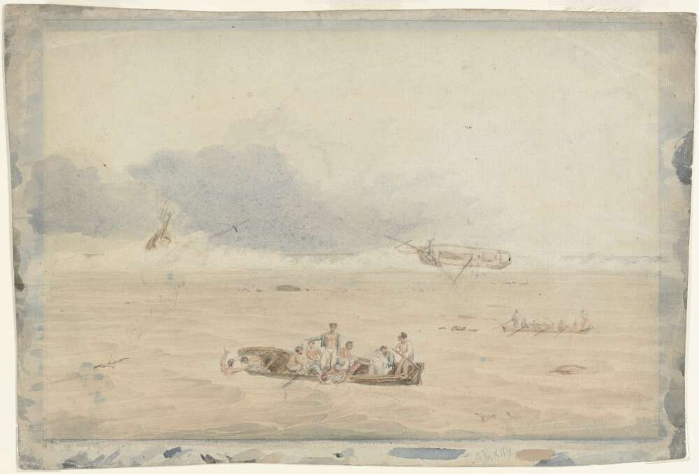
Figure 10 William Westall, The Wreck of the Porpoise
Westall later produced two watercolours of the event at Wreck Reef: – the Wreck of the Porpoise (Fig 10)[16] and Wreck Reef Bank (Fig 11)[17], which shows the survivors’ camp which was quickly established.
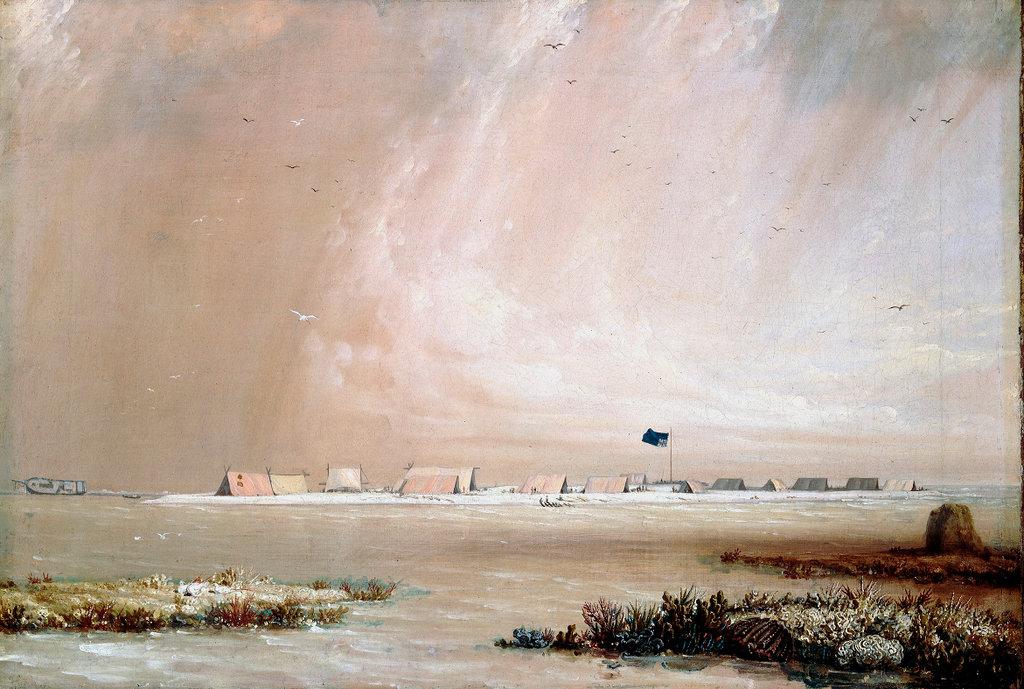
Figure 11 William Westall, Wreck Reef Bank
Ten days after the wreck, when it was accepted that the third ship the Bridgewater was definitely gone, Flinders & some officers set sail southward for Port Jackson to get help.
The rest of the survivors settled in to a fairly well-provisioned wait on the sandbank – they had food, water, livestock, and tents made from rescued sails. According to an anonymous account of the wreck published three years later in the Naval Chronicle, later credited to James Purdie:
There was a good natured friendly disposition, with the strictest order and regularity prevailing among all ranks; and every one found out resources of amusement, according to the peculiar bent of his own disposition. [18]
Westall’s focus in this time – once he had recovered from the trauma of another shipwreck – was his sketches. He produced sketches which we see here of the wreck incident itself, and life awaiting rescue on the sandbank. Legend has it that Westall laid his damaged drawings out to dry, and they were further destroyed by being trampled by sheep. I say as legend has it, as I first read this in one narrative but have not been able to confirm it. Another version of this story from Marie Estensen says:
a few of his drawings were destroyed and quite a number left wet but retrievable. They incurred further damage, it seems, when on the reef young Franklin let the sheep run across them as they lay drying on the sand.[19]
I have looked through all of the damaged drawings I can, and have found no hoof print. But plenty of water damage: some minor, such as along one edge of a sketch of Thirsty Sound[20], and some major, such as on his rendering at Port Curtis.[21]
Figure 12 William Westall, Thirsty Sound, view westward along the Sound, National Library of Australia
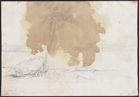
Figure 13 William Westall, Port Curtis, National Library of Australia
Life was precarious in ways which we cannot quite comprehend in the privileged comforts of the 21st century.[22] For Westall, the damage to his sketches might have been an annoyance, but perhaps incommensurate to the trauma of sheer survival. Then again, the risk of shipwreck would have been a calculated one in the days of sail, similar to the risk of malaria and other tropical diseases, or dying from a small cut on your foot in an age before antibiotics.
For the Admiralty, who were paying his wage and expecting lush illustrations for publication, the loss of the sketches and finished drawings were much more concerning. The endgame, for the Flinders journey, was publication – and there was an insatiable public demand. As Isabella Alexander wrote, 'Travel writing was the most popular literary genre of the period, responding to and fuelling popular interest in science, the natural world, the exotic, trade opportunities, and the prestige of imperial acquisition.' [23]
At the end of 1803, the Admiralty were waiting impatiently in London for Flinders’ charts and the artwork for publication, including that of Westall. Yet, it was not to be that simple.
It took a few weeks for Flinders to return to Wreck Reef with rescue ships, which took divergent routes. Westall and his surviving sketches were picked up from Wreck Reef and taken to Canton (Guangzhou) in China, while Flinders and his all-important charts sailed straight across the Indian Ocean. Flinders might have been seen to take the more expedient route, but there was a significant complication: England was currently at war with France, and when Flinders was forced to land at Mauritius, then a French holding. He was detained – along with his papers - for seven years.
Meanwhile in Canton, which at that time was a bustling entrepot of merchants and adventurers from all over the world, Westall began to ignore the directions of the Admiralty to return at once to England. He toured Canton and produced more sketches and art, as it fitted his idea of the picturesque. He then set sail for Ceylon (Sri Lanka). He felt like he had been misled by the admiralty, due to the barrenness and lack of interest of the Australian landscapes, and effectively said so in correspondence to Joseph Banks.[24]
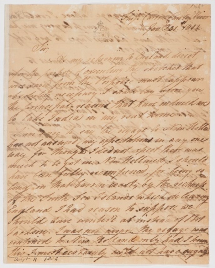
Figure 14 Letter from William Westall to Joseph Banks, 1804
Westall was immediately fired by the admiralty, and told to return his drawings, which were government property, by the terms of his contract. Banks’s correspondence from Westall lists a total of 140 extant drawings. Also listed in detail were drawings 146-157, which were all ‘very much damaged’.[25]
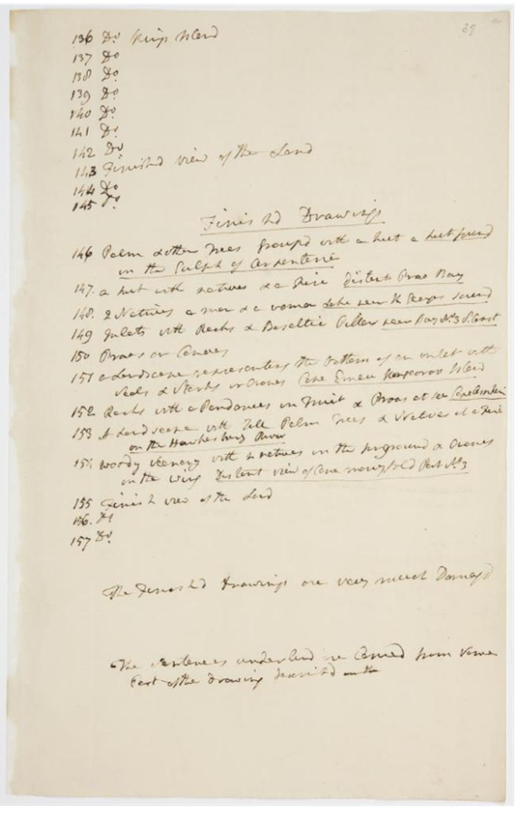
Figure 15 List of damaged drawings, Banks Papers, State Library of New South Wales.
Westall and his damaged sketches and artwork finally arrived back in UK at the end of 1804, over a year after the shipwreck at Wreck Reef. Undeterred, he sailed again for Madeira and Jamaica, this time specifically for the picturesque.[26] And when he held his first solo show in 1806, no Australian images used.
Westall’s work remained the property of the Admiralty and the designated publisher. And due to Matthew Flinders’ lengthy imprisonment on Mauritius, it was a decade before the all-important publication of Flinders journey (in 2 volumes plus Atlas) was able to be finalised.[27]
During this time, Westall fulfilled his obligations to the Admiralty, producing illustrations for publication plus a series of oil paintings which are currently on show at the Royal Museum at Greenwich.

Figure 16 William Westall paintings, Pacific Encounters exhibition, Royal Museum Greenwich (photo by author)
In the early 19th century, the value in Westall’s work – from badly damaged field drawings, to their presence as lithographs in the book, and the oil paintings – was in their ultimate usefulness to the Admiralty. In an era of rival imperial ambitions, the publication of Flinders’ journals and charts, with Westall’s imagery, claimed ownership and the very definition of Australia by the British Crown (even though New Holland still appears on his chart).
These books and especially the images served an important cultural role for the British empire. While a lot of sketches and artwork produced during exploration and early colonial encounters acted as perhaps a coded record or signifier of empire, Westall’s work in this period always occupied an explicit and public propaganda role. They were always objects, almost weapons of Empire.
William Westall’s sketches were NEVER William Westall’s sketches.
Leonie Stevens
[1] William Westall, self-portrait C1820, National Library of Australia. http://nla.gov.au/nla.pic-an7692976-v
[2] Isabella Alexander, 2023, Copyright, Nature, and Travel Narratives: Publishing Cook’s Voyages, in Intellectual Property and the Design of Nature. Edited by: Jose Bellido and Brad Sherman, Oxford University Press.
[3] Most are located at National Library of Australia in the PIC Solander Box, and are digitised and available online.
[4] Westall, William. 1801. King George's [i.e. George] Sound, view from the north-west, National Library of Australia, http://nla.gov.au/nla.obj-138874929
[5] Westall, William. 1802. Thistle Island, National Library of Australia, http://nla.gov.au/nla.obj-138876122
[6] Westall, William 1802, Sydney, Government House, National Library of Australia, https://nla.gov.au/nla.obj-138873721/view
[7] Westall, William. 1802. Murray Isles [i.e. Islands] http://nla.gov.au/nla.obj-138892299
[8] Shellam, Tiffany. 2020. Meeting the Waylo: Aboriginal Encounters in the Archipelago. 1st ed. Perth: UWA Publishing.
[9] Macassans at Victoria, Port Essington by HS Melville, National Museum of Australia. https://digital-classroom.nma.gov.au/images/macassans-victoria-port-essington-drawn-1845
[10] See Campbell Macknight’s seminal 1976 work, The voyage to Marege' : Macassan trepangers in Northern Australia, Carlton, Vic. : Melbourne University Press.
[11] Urwin, C., Bradley, J., McNiven, I.J., Russell, L. & Yulianti Farid, L. (2023). Re-assessing regional chronologies for island southeast Asian voyaging to Aboriginal Australia. Archaeology in Oceania 58(3). pp. 245–274.
[12] https://iview.abc.net.au/show/compass/series/38/video/RN2311H005S00
[13] Findlay, Elisabeth, and William Westall. 1998. Arcadian Quest : William Westall’s Australian Sketches. Parkes, A.C.T: National Library of Australia
[14] William Westall, View of Malay Road from Pobassoo's Island, February 1803. Completed 1809-12. Royal Museum Greenwich https://www.rmg.co.uk/collections/objects/rmgc-object-15616
[15] Lithograph of the wreck: Royal Museum Greenwich, https://www.rmg.co.uk/collections/objects/rmgc-object-110203
[16] Westall, William, The Wreck of the Porpoise, Flinders Expedition, National Library of Australia, https://catalogue.nla.gov.au/catalog/860403
[17] Westall, William, 'Wreck Reef Bank, taken at low water, August 1803’ Royal Museum Greenwich, https://www.rmg.co.uk/collections/objects/rmgc-object-12656
[18] Anonymous author The Naval Chronicle 1906 V16, 228.
[19] Estensen, Marie, 2004, The life of Matthew Flinders. Allen & Unwin, p 300
[20] Westall, William. 1802. Thirsty Sound, view westward along the Sound, National Library of Australia, http://nla.gov.au/nla.obj-138891246
[21] Westall, William. 1803. Port Curtis. National Library of Australia, http://nla.gov.au/nla.obj-138881672
[22] I say privileged, because peoples who are seeking refuge across the waters, enduring the violence and deprivations of war, trying to get through the day while homeless can readily grasp it.
[23] Alexander, Isabella 2023, Copyright, Nature, and Travel Narratives: Publishing Cook’s Voyages, in Intellectual Property and the Design of Nature. Edited by: Jose Bellido and Brad Sherman, Oxford University Press.
[24] Letter received by Banks from William Westall, 31 January 1804. Banks Papers/Series 23.44. State Library of New South Wales. https://collection.sl.nsw.gov.au/record/16AXkvDn
[25] Banks Papers/Series 23.44.
[26] Findlay, Elisabeth, and William Westall. 1998. Arcadian Quest: William Westall’s Australian Sketches. Parkes, A.C.T: National Library of Australia
[27] Matthew Flinders, A Voyage to Terra Australis… , London: W. Bulmer and Co. for G. and W. Nicol, 1814.